PRESS RELEASE
Launch of a Geospatial Platform for supporting sustainable cropland and water management in Libya
An essential tool for making informed decisions in agricultural development using advanced information and data.
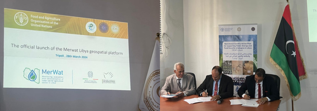
Tripoli, 28th March: The Italian Agency for Development Cooperation (AICS) and the Food and Agriculture Organization of the United Nations (FAO), in cooperation with the Ministry of Water Resources, the Ministry of Agriculture and Livestock, and the Libyan Centre for Remote Sensing and Space Science are launching the “MerWat-Libya” Geospatial Platform. This platform will provide geospatial information to support water resource management in Libya and will enable national partners to access a vast amount of spatial information to support sustainable water and crop production while considering available natural resources.
The Geospatial platform is one of the main results of the project “Monitoring, Evaluation and Rationalization of Water Use for the Agricultural Sector in Libya”, funded by the Italian Ministry of Foreign Affairs and International Cooperation (MAECI), through a 830,000 euros-grant. This innovative tool serves as a hub for digital data exchange and dialogue, underscoring the growing importance of geospatial technology in modern agriculture. It offers comprehensive capabilities for accessing, storing, processing, and analyzing spatial data and it is essential for making informed decisions in agricultural development using advanced geospatial information and data. It also incorporates datasets on crop types, cultivated field boundaries, hydrological basins, and soil classification, empowering stakeholders with precise information for informed decision-making.
During the launch event, the MerWat-Libya Geospatial Platform was presented to key stakeholders in the land and water management, agriculture and environment sectors. The presentation provided a clear overview of the structure, components and usage guidelines of the platform, and was attended by representatives from institutions, academia, science and civil society.
Deputy Ambassador Riccardo Villa, underscores the critical role of the MerWat-Libya Geospatial Platform in strengthening the partnership between Italy and Libya. “This technological leap marks a significant stride towards shared goals of sustainability and resilience in agricultural practices. A demonstration of Italy’s leadership and commitment to leveraging knowledge and technology for impactful decisions in the agriculture and environment sectors, in close collaboration with the UN and for the direct benefit of partner countries.”
A. Maki Abdourahman, representing FAO-Libya, underlined the importance of the achievement of this project. He highlighted the fruitful cooperation with all national partners and underlined that the MerWat-Libya Geospatial Platform is now operational as a national information platform. It supports sustainable land and water management by providing access to information on crop and water use and sustainable practices. This is a significant step forward in water, agriculture and environmental management in Libya,” said M. A.Maki, adding that the platform is embedded in FAO’s open-access Hand in Hand (HIH) for evidence-based acceleration of agricultural transformation towards food security.
The core team of national institutions, including the Ministry of Water Resources, the Ministry of Agriculture and Livestock, and the Libyan Remote Sensing and Space Science, presented, approved and signed a partnership and collaboration agreement for the Libyan Geospatial Platform to ensure its sustainability.
A visit to the offices hosting the platform, including the Ministry of Water Resources, the Ministry of Agriculture and Livestock, Libya Remote Sensing and Space Science and Fezzan, concluded the formal launch of the MerWat-Libya Geospatial Platform. Looking forward, the MerWat-Libya Geospatial Platform aims to integrate emerging technologies, expand data resources, and enhance user experiences. This commitment to innovation is expected to foster sustainable agricultural practices, improve water resource management, and contribute to Libya’s environmental and economic development.
For further information and to explore the MerWat-Libya Geospatial Platform, please visit: https://data.apps.fao.org/merwat-libya/?lang=en
For more information about the project:
Press contact:
Faten Aouadi, FAO Communication Officer
Email: faten.aouadi@fao.org
Marion Piccio, AICS Communication expert
Email: marion.piccio@aics.gov.it